Damage Assessment Mapping Module
The Damage Assessment Mapping Module (DAMM) for Portland NET is a mobile device-based tool to document and map impacts of a disaster, and electronically transmit that information to the Portland Emergency Coordination Center (ECC). It is powered by Survey123 for ArcGIS. It is, essentially, an electronic version of NET Form 1 for damage assessment. ECC personnel can immediately use information sent to them from DAMM to allocate resources for response and recovery. Volunteers can document assessments with the DAMM even in the absence of internet service, though internet service is required to transmit the reports completed by a user.
Every NET volunteer and ATV with a smartphone should download the software onto their device and know how to use it in the field.
...
..
Program Overview
The Damage Assessment Mapping Module (DAMM) is one of the most important communication tools available to NET volunteers. The tool promotes accuracy, consistency, and efficiency in collecting post-disaster data for use in high-level decision making.
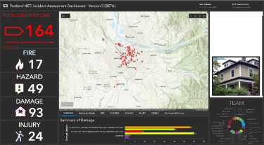
Observations inputted to the DAMM via the Survey123 app are relayed to an Operational Dashboard (fig. 1) displayed to emergency response planners in Portland’s Emergency Coordination Center (ECC). In turn, ECC personnel will use the data to assemble a highly detailed situational awareness picture and allocate response resources accordingly and (where possible) expeditiously. Data inputted to the DAMM will also be critical for applying for federal relief aid and other resources in the aftermath of a major disaster.
Practical DAMM applications in a disaster
The DAMM is set up for volunteers to perform a site-to-site assessment, with one survey submitted per site. While this assessment method is labor intensive, it is highly accurate and used when a higher degree of confidence in the information is required. PBEM recommends that planned use of the DAMM appear in all NET Operations Plans with a Team Leader assigning at least one or two volunteers to begin making reports with it after the acute phase of disaster response has passed (probably 24 hours after an earthquake, for example). Volunteers using the DAMM assess each property site in their neighborhood, site by site, and reports should include undamaged property (in the survey, there is an option to indicate up front that a volunteer observes no damage).
Who is allowed to use the DAMM?
NET and COAD volunteers above all others. But, NET and COAD volunteers can also “deputize” spontaneous volunteers as needed. In the survey, a deputized spontaneous volunteer should use their own name but the badge number of the volunteer who deputized them.
...
Loading DAMM Onto Your Mobile Device
Download Survey123 onto your device
Downloading the Survey123 application is easy on a mobile device such as a tablet or phone. Simply go to your app store and search for “Survey123 for ArcGIS”.
Getting and opening the survey
Once you have the Survey123 app on your phone, you must next load the DAMM survey into the app.
- From your device, click on this link: https://arcg.is/1rXPL1; or, use your device to scan the QR code in the right margin of this article. You DO NOT need to be in the Survey123 app, and you DO NOT need to be signed in to the app.
- When you click on the link or scan the QR code, you will see a screen that gives you the option to either open the survey in a web browser or in the Survey123 app. Select: Open in the Survey123 field app. You only need to do this step once unless a new version of the survey comes out. If that happens, PBEM will notify you that there is a new survey version and will send you a link. You can then delete the old survey from your device (see Deleting an outdated survey in this article).
- After you open in the Survey123 field app, you will see the welcome screen. On the welcome screen, select Continue without signing in. This is particularly important because the most common question we get is: "how do I sign in?" You do not sign in.
- If the "My Survey" page appears, select the survey you wish to use, which should be the latest version available.
- To begin a new site report and begin entering data select Collect on the next screen. The survey will appear and you can input your observations.
...
Submitting a DAMM Survey
After going through the Form Fields and completing the report, a volunteer can send those observations to the ECC. To do this, click the checkmark icon at the bottom right of the screen. Doing so prompts three options:
- Send now: If the volunteer has a reliable internet connection and is ready to submit the data, they should select "Send now". Observations from the report will show up in real-time on the ECC Dashboard.
- Continue the survey: If you want to go back to edit any item on the form before it is submitted, the volunteer should click "Continue The Survey".
- Save in outbox: If the volunteer does not have an internet connection (Wi-Fi /cellular), they should click "Save in Outbox" and data will be saved to their device (local copy) where it can be uploaded when a connection becomes available. See section Outbox for details clearing the outbox.
Outbox
In instances
...
DAMM Form Fields
The field structure and interface of the DAMM is designed for quick and detailed reporting. Though the number of fields might intimidate a new user, note that most of them are "selection" fields which often require no more than a "yes" or "no", with one answer already selected as a default. With practice, a typical volunteer will complete a single site report in only a few minutes.
The table below lists each of the reporting fields, broken up into sections such as "Site Details" or "Damage Details". The fields are not numbered in the DAMM, but numbered in this article for easy reference. Most fields do not require a response; the ones that do are indicated with a checkmark in the table. Each field has a "type", indicating the type of information to input (Fig. 2). The more common ones are:
- Selection, presented as a series of radio buttons, and the user can only choose one of the given options.
- Checkboxes are similar to Selection radio buttons; but, a user can select multiple checkboxes.
- Text is a text field the user can type in to. Though text can paint a more detailed picture, text boxes appear rarely because typing slows down a responding user.
- Integer is a field with +/- buttons so a user can quickly input a number.
The "Notes" column includes selection options and special attributes, if any, of a field.
| # | Field Name | Required? | Field Type | Notes | ||
|---|---|---|---|---|---|---|
| A | Observer Details...
This section identifies the individual collecting data. Users can save time by setting responses to these fields as Favorite Answers. | |||||
| 1 | Person Reporting | ✓ | Text | Name of volunteer as it appears on their volunteer badge, if they have one. | ||
| 2 | Neighborhood Emergency Team | ✓ | Drop-down | Select your Team from the dropdown list. | ||
| 3 | NET ID Number | ✓ | Text | Volunteer's badge number; if the volunteer does not have one, they should use the badge number of a Team Leader. | ||
| 4 | Date & Time Observed | N/A | Date/Time | Autofilled by the app. It will record the time, date, and location from when/where you press "Collect". Be sure you are in the correct location before pressing "Collect". | ||
| 5 | Incident Type | ✓ | Drop-down | What event type caused the damage? | ||
| 6 | Incident Name | ✓ | Text | Enter the name of the incident as provided by the Incident Commander. If you do not have an incident name, simply type in “N/A”. | ||
| B | Site Details | |||||
| 7 | Location of the assessment | N/A | Geopoint | Autofilled by the app; the system will automatically record the latitude/longitude when you press "Collect" to begin the survey. | ||
| 8 | Street Address | Text | ||||
| 9 | Zip Code | |||||
| 10 | Do you see anything? | ✓ | Selection | Yes or No. All fields below this point are hidden from view if "No" is selected for this field. If there are no observable problems at the site, simply select "No" and send the report. Then, move on to the next site. | ||
| 11 | Are there any immediate needs? | Selection | Yes, No, or Unsure. "Immediate" is any condition for which a reasonable person would dial 9-1-1 to get help. | |||
| 12 | Site Identification Photo | Upload | App will connect to device camera to take a picture, or a saved file may be selected. | |||
| C | Fire Details | |||||
| 13 | Fire | Selection | Yes or No. Is there evidence of a fire? Fire fields below this point are hidden if "No" is selected for this field. | |||
| 14 | Fire, Actively Burning? | ✓ | Selection | Yes or No. | ||
| 15 | Fire Notes | Text | Input any notes about the fire. | |||
| D | Hazard Details | |||||
| 16 | Hazard | ✓ | Selection | Yes or No. Are hazards present? Hazard fields below this point are hidden if "No" is selected for this field. | ||
| 17 | Gas Leak | Selection | Yes; leave unselected if "No". | |||
| 18 | Water Main Break | Selection | Yes; leave unselected if "No". Is there standing water present? | |||
| 19 | Electric Line Down | Selection | Yes; leave unselected if "No". | |||
| 20 | Chemical | Selection | Yes; leave unselected if "No". | |||
| 21 | Other (Please Describe) | Checkboxes | Can select any of the following: Landslides, Downed trees, Bridges out, Leaking septic, Other (Provide Details) | |||
| 22 | Hazard Notes | Text | Input any notes about the hazard(s). | |||
| E | Damage Details | |||||
| 23 | Damage | ✓ | Selection | Yes or No. Do you observe ay damage? Damage fields below this point are hidden if "No" is selected for this field. | ||
| 24 | Structure Damage | ✓ | Selection | Can select one of the following: Affected, Minor, Major, Destroyed, Inaccessible, Unaffected. | ||
| 25 | Primary Occupancy | ✓ | Selection | Can select one of the following: Business, Single Family Home, Multi-Family Home, Mobile Home, Government, Other. | ||
| 26 | Damage Notes | Text | Provide details about the observed damage. | |||
| F | Injury Details | |||||
| 27 | Injury | ✓ | Selection | Yes or No. Injury fields below this point are hidden if "No" is selected for this field. Injury details will be displayed in a separate map to alert Incident Managers of the severity and extent of injuries. It is important to record actual address locations to assist first responders. | ||
| 28 | Minor | Integer | Use + or - to indicate the number of injured persons with this class of injuries at this site. | |||
| 29 | Delayed | Integer | Use + or - to indicate the number of injured persons with this class of injuries at this site. | |||
| 30 | Immediate | Integer | Use + or - to indicate the number of injured persons with this class of injuries at this site. | |||
| 31 | Deceased | Integer | Use + or - to indicate the number of injured persons with this class of injuries at this site. | |||
| 32 | Trapped | Integer | Indicate if occupants are trapped. Use + or - to indicate the number of injured persons with this class of injuries at this site. | |||
| 33 | Injury Notes | Text | ||||
| G | Misc. | |||||
| 34 | Is Road Access Blocked? | Selection | Yes or No. | |||
| 35 | Are Dangerous Animal(s) Present? | Selection | Yes or No. | |||
| 36 | Further Actions | Checkboxes | Check the boxes below only if further actions are needed. Selection any of the following: Barricade Needed, Detailed Evaluation Recommended, Other. | |||
| 37 | Comments | Text | Final optional comments, limit of 255 characters. | |||
| H | Supplemental Questions | |||||
| 38 | Do you have time to provide more information? | ✓ | Selection | Yes or No. If a volunteer has to move along quickly, indicate "No" and send the report, and move to the next site. | ||
| I | Building Details | |||||
| 39 | Building Name | Text | Any identifying title on the building. | |||
| 40 | Building contact/phone | Text | Primary phone to reach someone working or residing at this building. | |||
| 41 | Owner or Renter | Selection | This question assumes you are in contact with a building occupant. You can select either Owner, Renter, or Unknown. | |||
| 42 | Number of stories ABOVE Ground | Integer | ||||
| 43 | Number of stories BELOW ground | Integer | ||||
| 44 | Number of residential units | Integer | If unknown if there are any residential units, enter "0". | |||
| 45 | Number residential units not habitable | Integer | If unknown, enter "0". | |||
| 46 | Are Utilities Functional | Selection | Yes, No, or Unknown. | |||
| 47 | Is this a historical building? | Selection | Yes, No, or Unknown. | |||
| 48 | Estimated Square Footage of Damaged Structures | Integer | When a user clicks into this field, a calculator will appear to aid the estimate. | |||
| 49 | Is this property in subsidized housing? | Selection | Yes, No, or Unknown. | |||
| J | Demographic Questions | |||||
| 50 | Number of People at This Location | Integer | ||||
| 51 | Number of Individuals Greater than 65 yrs | Integer | ||||
| 52 | Number of Individuals Less than 5 yrs | Integer | ||||
| END OF SURVEY | ||||||
...
Taking a Photo in DAMM
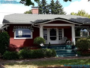
One key step to good incident observation is taking photographs of the scene. The photos are one of the best ways to demonstrate the extent of damage sustained from an incident. Incident commanders, insurance adjusters, FEMA representatives, and property owners will all get a better idea of conditions with photographs. Keep in mind that you are simply trying to preserve evidence, not win photography awards. The built-in camera from your mobile device will capture details. Also, the built-in watermark will add a timestamp and detailed location to each photo that will link your photos to the location.
How to take a photo in DAMM
- Activate the camera: Pressing the camera icon button will activate the camera of your mobile device.
- Taking the picture: Point your mobile device at the subject you wish to report (i.e. fire, damage to building, fallen tree) and press the photo button. Note the style of the icons will vary based on phone model. Take photos in horizontal orientation with good Lighting.
- Additional photos: After taking a photo, an icon will appear that allows you to take an additional photo. The system allows for a maximum of three (3) photos for each report. Example uses for additional photos:
- Multiple incidents at a single observation point (i.e. fire and structural damage);
- A different angle of the same incident;
- Thorough documentation of damage.
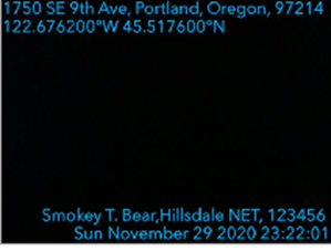
- Watermark: For documentation purposes, the system will automatically embed each photo with the following:
- Site address (top left, line 1)
- Latitude/Longitude (top left, line 2)
- Observer name (bottom right, line 1)
- NET Team (bottom right, line 1)
- Badge number (bottom right, line 1)
- Date and time, 24 hour format (bottom right, line 2)
What to consider when taking a site photo
Capture the details
When thinking about what to photograph, it may not be obvious which details will become important later on. Generally, the more pictures you take, the better. However, the DAMM only allows for three photos to send with each report, so choose your photographs carefully.
Take pictures of:
- The structure and damage sustained;
- Other structures at the address, and the damage they sustained;
- The overall site (i.e., the intersection, parking lot, or other location);
- The environment/weather conditions; and
- Any visible bodily injuries (if feasible and consented to).
Take photos from different angles and distances
It's best to take a wide variety of photos. Snap photographs from at least three different angles and distances. For close-up photographs, take the picture from one to five feet from the subject. Also take medium distance photographs (from 10 to 15 feet away) and long distance or panoramic photographs (from 20 or more feet away) when it is safe and makes sense to do so.
When taking pictures of the surrounding area, try to keep a common landmark in each of the photographs to demonstrate distance and scale. Also be aware of sunlight and weather conditions and how those might affect your photographs, especially those relating to damage. If possible, use different flash intensities, and/or take the same photographs with and without flash.


