Team Service Areas: Difference between revisions
mNo edit summary |
mNo edit summary |
||
| (7 intermediate revisions by the same user not shown) | |||
| Line 1: | Line 1: | ||
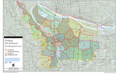
A Team's Service Area refers to the geographic area within which a NET administers their Operations Plan; it can be thought of as their "turf" and the area they plan to respond inside of in the event of a disaster. Most Service Areas conform with neighborhood boundaries, while others include multiple neighborhoods or a part of a neighborhood. Service Areas are proposed to PBEM by Team Leaders, and PBEM provides final approval. A team should evaluate their Service Area every time they update their Operations Plan. | [[File:FMAmap.jpg|alt=Map of PF&R FMAs.|thumb|''At one time, a team's Service Area was contiguous with their local Fire Management Area (FMA).''|400x400px]]A Team's Service Area refers to the geographic area within which a NET administers their Operations Plan; it can be thought of as their "turf" and the area they plan to respond inside of in the event of a disaster. Most Service Areas conform with neighborhood boundaries, while others include multiple neighborhoods or a part of a neighborhood. Service Areas are proposed to PBEM by Team Leaders, and PBEM provides final approval. A team should evaluate their Service Area every time they update their Operations Plan. | ||
<br /> | |||
< | <br /> | ||
__TOC__ | __TOC__ | ||
< | <br /> | ||
<br /> | |||
== Background == | == Background == | ||
Service Area policies changed several times since Portland NET started in 1994, often reflecting the reach of the program and interests of volunteers. In the first years of NET, Service Areas conformed with [[Portland Fire & Rescue|Portland Fire & Rescue fire management areas]] (FMAs). As the number of NET volunteers increased over the years, Service Area boundaries shifted to follow Portland's neighborhood system. That is how most Service Areas boundaries are drawn today, but PBEM encourages teams to reconsider their boundaries and "right size" them to match resources and team priorities. Creating more nuanced boundaries is also more plausible than in past years thanks to the increased availability of GIS mapping systems. | Service Area policies changed several times since Portland NET started in 1994, often reflecting the reach of the program and interests of volunteers. In the first years of NET, Service Areas conformed with [[Portland Fire & Rescue|Portland Fire & Rescue fire management areas]] (FMAs). As the number of NET volunteers increased over the years, Service Area boundaries shifted to follow Portland's neighborhood system. That is how most Service Areas boundaries are drawn today, but PBEM encourages teams to reconsider their boundaries and "right size" them to match resources and team priorities. Creating more nuanced boundaries is also more plausible than in past years thanks to the increased availability of GIS mapping systems. | ||
<br /> | |||
<br /> | |||
== Job Aid: Creating a Team Service Area Boundary == | == Job Aid: Creating a Team Service Area Boundary == | ||
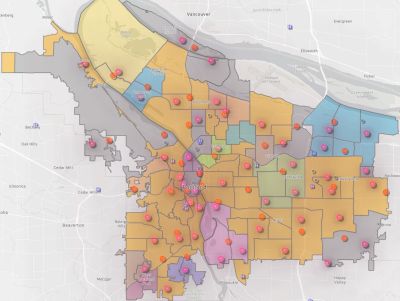
[[File:Team Service Areas.jpg|alt=NET Team Service Areas on August 24, 2023.|thumb|''NET Team Service Areas on August 24, 2023.'']] | [[File:Team Service Areas.jpg|alt=NET Team Service Areas on August 24, 2023.|thumb|''NET Team Service Areas on August 24, 2023.''|400x400px]] | ||
PBEM offers the following rules and guidance to NETs when developing their Service Area Boundaries: | PBEM offers the following rules and guidance to NETs when developing their Service Area Boundaries: | ||
| Line 31: | Line 29: | ||
# Does the team have the resources to conduct operations safely and effectively inside the proposed Service Area? | # Does the team have the resources to conduct operations safely and effectively inside the proposed Service Area? | ||
# Boundaries ''can'' change over time; a team is not "stuck" with the boundaries | # With that first consideration, PBEM prescribes no size requirements. The Service Area can theoretically span across neighborhoods or be a cluster of houses on a block. The idea is that the size of a Service Area match the objectives of the volunteers participating in it. | ||
# Boundaries ''can'' change over time; a team is not "stuck" with the boundaries PBEM approves. A new proposal can be submitted for approval every time the Operations Plan is updated (at least once every two years). Boundaries may expand or retract. | |||
# Is there an appropriate location inside the Service Area to place a [[NET Staging Areas|NET Staging Area]]? | # Is there an appropriate location inside the Service Area to place a [[NET Staging Areas|NET Staging Area]]? | ||
# How many NET volunteers live inside the Service Area? If you're not sure, a Team Leader can request member addresses from PBEM and drop them into an application such as [https://www.batchgeo.com/ BatchGeo] (as long as the address information is kept strictly confidential). To be a member of a team, a volunteer does not have to reside inside the team's Service Area, but does need to be within walking or biking distance of the [[NET Staging Areas|NET Staging Area]]. | # How many NET volunteers live inside the Service Area? If you're not sure, a Team Leader can request member addresses from PBEM and drop them into an application such as [https://www.batchgeo.com/ BatchGeo] (as long as the address information is kept strictly confidential). To be a member of a team, a volunteer does not have to reside inside the team's Service Area, but does need to be within walking or biking distance of the [[NET Staging Areas|NET Staging Area]]. | ||
# NETs can use Portland's Community Resilience mapping tool to draw borders, shade areas, and print maps. A direct link is [https://pdx.maps.arcgis.com/apps/webappviewer/index.html?id=57d23ac6eaf94c9784b31231dd710a2f HERE]. | # NETs can use Portland's Community Resilience mapping tool to draw borders, shade areas, and print maps. A direct link is [https://pdx.maps.arcgis.com/apps/webappviewer/index.html?id=57d23ac6eaf94c9784b31231dd710a2f HERE]. | ||
=== Submitting to PBEM === | === Submitting the Service Area to PBEM for Approval === | ||
After a NET agrees on Service Area boundaries, the Team Leader submits them to their PBEM Liaison for approval. There is no prescribed format for the submission as long as they are clear. The best way to do that is to email a map with the service area shaded in, along with specific descriptions of what streets (or other features) are the boundaries (e.g. "North to E Burnside, east to SE 82nd, south to SE Taylor, west to SE 73rd"). PBEM will either approve the Service Area, or send it back with needed or suggested modifications. | |||
Once PBEM approves the Service Area, the NET can proceed with updating the rest of the Operations Plan. The team's service area will be published to the [https://pdx-net.maps.arcgis.com/home/index.html NET Map and Directory]. | Once PBEM approves the Service Area, the NET can proceed with updating the rest of the Operations Plan. The team's service area will be published to the [https://pdx-net.maps.arcgis.com/home/index.html NET Map and Directory]. | ||
Latest revision as of 13:27, 31 October 2023
A Team's Service Area refers to the geographic area within which a NET administers their Operations Plan; it can be thought of as their "turf" and the area they plan to respond inside of in the event of a disaster. Most Service Areas conform with neighborhood boundaries, while others include multiple neighborhoods or a part of a neighborhood. Service Areas are proposed to PBEM by Team Leaders, and PBEM provides final approval. A team should evaluate their Service Area every time they update their Operations Plan.
Background
Service Area policies changed several times since Portland NET started in 1994, often reflecting the reach of the program and interests of volunteers. In the first years of NET, Service Areas conformed with Portland Fire & Rescue fire management areas (FMAs). As the number of NET volunteers increased over the years, Service Area boundaries shifted to follow Portland's neighborhood system. That is how most Service Areas boundaries are drawn today, but PBEM encourages teams to reconsider their boundaries and "right size" them to match resources and team priorities. Creating more nuanced boundaries is also more plausible than in past years thanks to the increased availability of GIS mapping systems.
Job Aid: Creating a Team Service Area Boundary
PBEM offers the following rules and guidance to NETs when developing their Service Area Boundaries:
Service Area Rules
PBEM will only approve Service Areas if they conform with these rules:
- Service Area boundaries shall not overlap with the Service Area boundaries of another team. "Enclaved" boundaries are acceptable.
- Exclaves are not permitted; except in unusual circumstances, boundaries must be contiguous.
General Guidance/Suggestions
The following conditions are not required, but teams should undertake due diligence to propose a Service Area that:
- Is mostly inside City of Portland city limits.
- Includes at least one BEECN and one fire station.
- Is square/rectangular-shaped with four sides (they are significantly easier to process on mapping tools). This will difficult to avoid for some teams that abut freeways, curvy streets, or waterways. Teams should do their best here. PBEM will reject highly gerrymandered Service Areas.
Considerations
- Does the team have the resources to conduct operations safely and effectively inside the proposed Service Area?
- With that first consideration, PBEM prescribes no size requirements. The Service Area can theoretically span across neighborhoods or be a cluster of houses on a block. The idea is that the size of a Service Area match the objectives of the volunteers participating in it.
- Boundaries can change over time; a team is not "stuck" with the boundaries PBEM approves. A new proposal can be submitted for approval every time the Operations Plan is updated (at least once every two years). Boundaries may expand or retract.
- Is there an appropriate location inside the Service Area to place a NET Staging Area?
- How many NET volunteers live inside the Service Area? If you're not sure, a Team Leader can request member addresses from PBEM and drop them into an application such as BatchGeo (as long as the address information is kept strictly confidential). To be a member of a team, a volunteer does not have to reside inside the team's Service Area, but does need to be within walking or biking distance of the NET Staging Area.
- NETs can use Portland's Community Resilience mapping tool to draw borders, shade areas, and print maps. A direct link is HERE.
Submitting the Service Area to PBEM for Approval
After a NET agrees on Service Area boundaries, the Team Leader submits them to their PBEM Liaison for approval. There is no prescribed format for the submission as long as they are clear. The best way to do that is to email a map with the service area shaded in, along with specific descriptions of what streets (or other features) are the boundaries (e.g. "North to E Burnside, east to SE 82nd, south to SE Taylor, west to SE 73rd"). PBEM will either approve the Service Area, or send it back with needed or suggested modifications.
Once PBEM approves the Service Area, the NET can proceed with updating the rest of the Operations Plan. The team's service area will be published to the NET Map and Directory.

